| Pristine waters of the West Fork November 18, 2025 by Editor Baseline water quality established near potential rare earth mine site by Michael Howell The Bitterroot River Protection Association (BRPA) has released the results of a base-line study of the water quality in the upper West Fork of the Bitterroot River, documenting the status of the watershed in the area of a proposed rare earth element (REE) mine. According to Dr. David Chambers, founder and President of the Center for Science in Public Participation (csp2@csp2.org), who examined the monitoring results, “It looks like very good water. The very low sulfate values suggest no natural or mining acid drainage…right now I would call the water pristine.” “We are not surprised by these results,” said Andy Roubik, BRPA president. “It’s what you would expect to find over 700 miles inland at the very tip top of the Columbia River watershed.” “We believe the old adage, ‘you don’t know what you’ve got till it’s gone,’ doesn’t really hold water here in the Bitterroot,” said Roubik. “We believe that most people in the Bitterroot Valley know very well what they’ve got here, and we are not at all ready or willing to lose it.” According to Roubik, the lower portion of the Bitterroot River currently tests positive for lead contamination. A thorough investigation by Montana Department of Environmental Quality as part of its 2014 TMDL assessment on the mainstem of the Bitterroot River from Missoula to Stevensville, which included examination of abandoned mines in the Eightmile and Three Mile Creek drainages, failed to determine the source. However, the search did not include examination of the Victor area around the site of the Curlew Mine because that mine had already undergone a Superfund cleanup and was presumed to be clean. The Bitterroot Star discovered subsequently that old tailings from the Curlew Mine were being used extensively by the Ravalli County Road Department and other private contractors for graveling roads in the north valley area and even being used as fill in the installation of stream culverts. A study conducted by Bitterroot College UM hydrology professor George Furniss and graduate students confirmed lead contamination that could be traced back to the Curlew Mine tailings. A video of the study and results can be accessed on the BRPA website www.bitterrootriver.org (click on Bitterroot River Health Check and click on projects). “We don’t want the upper Bitterroot River to suffer the same fate and have an out-of-state company come in and contaminate a pristine watershed and potentially the entire Bitterroot River and leave the public to clean it up,” said Roubik. He said contamination from REE mining is documented to be worse than conventional mining, involving potential radioactive contamination and, in this case, potential asbestos contamination as well. “The Bitterroot River is the lifeblood of our valley,” said Roubik. “It is the foundation of the valley’s economy which is primarily based on agricultural and recreational enterprises, both of which require lots of clean water.” He said the Bitterroot River Basin is closed to any new water right appropriations due to the over-allocation of the resource already. “Mining operations, especially REE mining, require a huge amount of water and, unfortunately, they carry an extremely high potential for contaminating water in the process. It doesn’t make any sense to risk everything we have going for us here in the Bitterroot to put in a mine with such a high potential for spoiling it all at the tip top of our watershed.” Dr. Phillip Ramsey, a local scientist with years of experience working on the Superfund clean-up of the Clark Fork River and leader of the Bitterroot Clean Water Alliance which formed in opposition to the mine, is very much in agreement with Roubik.  Bitterroot River Protection Association volunteers Mark Van Loon, Doug Soehren, Larry Campbell and Michele Dietrich collecting water samples from Johnson Creek in the area of the proposed Sheep Creek Mine. Photo by Michael Howell. “Rare earth element mines use far more water and create more toxic and radioactive waste than other types of large surface mines,” said Ramsey. “Since 1980, every new large mine permitted in Montana has caused unanticipated, often severe, impacts to water quality, except for Montana Resources, in Butte.” He said the location for the proposed Sheep Creek Mine is remote, in steep terrain, and snowbound in winter, all factors that make environmental contamination more certain. He said Montana could easily become a world leader in critical mineral production, including rare earth elements, without sacrificing a pristine watershed in the Bitterroot and pointed to potential rare earth element production from existing sites like the Berkeley Pit in Butte, the piles of coal fly ash in Colstrip and the shuttered Columbia Falls Aluminum Smelter Superfund site. The Department of Defense is currently considering funding a $75 million grant to Montana Resources to build a rare earth element concentrator in Butte. He said supporting this project is a very good alternative to placing a new mine in one of Montana’s most valuable pristine watersheds. He recommends urging public officials to reconsider capping the Aluminum Smelter Superfund Site in Columbia Falls and instituting a gallium recovery operation there instead. He said the Colstrip fly ash contains extractable rare earth elements as well.  The pristine waters of the upper West Fork of the Bitterroot River sparkle in the morning light just below the proposed Sheep Creek Mine. US Critical Materials, owner of the Sheep Creek mining claims, is a private company headquartered in Salt Lake City, Utah with 2 to 10 employees. US Critical Metals Corp. is a publicly traded company that has an agreement with US Critical Materials to earn up to 75% joint venture interest in the property. The partnership allows US Critical Metals Corp to advance the rare earth projects identified by US Critical Materials, with the goal of establishing a domestic supply of critical minerals for national security and technology. US Critical Metals is headquartered in Vancouver, Canada. It is a subsidiary of European Lithium Limited, an active overseas mining exploration company, incorporated in the Virgin Islands, which wholly owns the Wolfsberg Lithium Project located in Austria. European Lithium holds 50.55% of the shares in US Critical Metals. No other shareholder holds more than 2% of the shares each. The partners have announced annually since 2023 that they are going to begin exploratory drilling on their claims in the area but each year have failed to do so. The most recent announcement was to start in September of 2025 but to date no Plan of Operation has been submitted, a requirement for mining on National Forest land. Photo by Michael Howell. According to Ramsey, the single biggest barrier to all this is retroactive liability under the Superfund law. “Anyone who handles contaminated material can be held strictly, jointly, and retroactively liable for the entire cleanup—even if they improve the site,” he said. “This deters companies from reprocessing mine waste or coal ash. Repealing or reforming that liability is the key to unlocking Montana’s economic potential and making new headwaters mines unnecessary.” Roubik said that establishing a baseline for the current water quality in the upper West Fork is a continuation of BRPA’s adopted mission since 2018 to establish a systematic set of permanent water quality monitoring stations across the entire Bitterroot River Watershed. Since 2018 the organization has established 23 monitoring sites on 10 tributaries and seven sites on the mainstem of the Bitterroot River. According to Roubik, due to limited funding, aside from the nutrient and stream flow parameters collected in the first two rounds of sampling, metal testing was confined to looking for arsenic, lead and selenium, which are the most common form of pollutants produced in any kind of mining operation. No detectable levels of arsenic, lead or selenium were found in any of the samples. In the final round of sampling they also tested for many other metals commonly associated with REE mining, including cadmium, calcium, copper, nickel, silver, zinc and chromium VI. No detectable levels of these metals were found in any of the samples. Roubik said the Sheep Creek Mine monitoring project totaled about $5,856 in laboratory analysis costs alone. “We could not have done it without a lot of help from our friends,” said Roubik. “We owe a special thanks to our compatriots in river protection, the Ravalli County Fish and Wildlife Association, the Friends of the Bitterroot and grants from the Cinnabar Foundation, the Rapp Family Foundation, Trout Unlimited, Farmers State Bank and several individual donors. Of course, we also owe a special thanks to the volunteers that did all the work: Mark Van Loon, Larry Campbell, Doug Soehren and Michele Dieterich.” Fish barrier being eliminated on North Burnt Fork Creek SEPTEMBER 10, 2024 Bitterroot Star 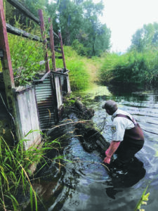 Lee Metcalf National Wildlife Refuge Manager Tom Reed removing a log jam at the fish barrier. Photo courtesy of Trout Unlimited. Lee Metcalf National Wildlife Refuge Manager Tom Reed removing a log jam at the fish barrier. Photo courtesy of Trout Unlimited.by Michael Howell A project to restore fish passage and streamside habitat at the mouth of North Burnt Fork Creek as it passes through Lee Metcalf National Wildlife Refuge is under way. It’s been a long time coming. The project was first envisioned as part of the Refuge Comprehensive Conservation Plan Goals for the Bitterroot River Floodplain and North Burnt Fork Creek back in 2012. A Draft Environmental Assessment was produced in November of 2022. The project, led by Lee Metcalf National Wildlife Refuge, Trout Unlimited and Montana Fish, Wildlife and Parks, will help reconnect the lower portion of North Burnt Fork Creek to its historical channel alignment, restoring riverine habitat to a portion of the creek that has been impounded and managed as wetland habitat for many years and eliminate a barrier culvert that has prevented fish from moving between the Bitterroot River and North Burnt Fork Creek for over 50 years. The project will open up 2.5 miles of North Burnt Fork Creek habitat to Bitterroot River fish, improving the overall health of the fishery and recreation opportunities. The current barrier structure – a set of two vertical pipes leading into two culverts – was historically used to impound and divert water for waterfowl habitat. It effectively impounds water but also created a full passage barrier to fish migrating between the Bitterroot River and North Burnt Fork Creek. Many fish species in the Bitterroot, including federally listed threatened bull trout and a Montana Species of Special Concern, Westslope Cutthroat trout, migrate into tributaries like North Burnt Fork Creek to spawn. The structure has encouraged sediment to precipitate out, which, over time, has made this area less beneficial for waterfowl. The project will place a new, larger, bottomless culvert to maintain public access throughout the trail system while also opening fish passage. According to the Environmental Assessment, the reason for selecting a bridged culvert over a spanned bridge is that it is cost effective and will also allow heavy equipment and emergency vehicles to pass over the creek, eliminating the need for, and disturbance of, creating an upstream low-water crossing. Eliminating the low water crossing also precludes the need to haul approximately 813 cubic yards of material off site from sloping the creek’s levees. Where North Burnt Fork Creek meets the water control structure, a smaller, ditched channel diverts a portion of water northwards. The channel is dry each summer. Under this action, this northward channel will be maintained for high flow events, but recontoured from its current, linear ditch form into a series of wetland swales. According to Bitterroot Trout Unlimited Project Manager Christine Brissette, plans also include a major effort to improve streamside riparian habitat for shade and cover. Reed canary grass, a highly aggressive non-native grass, has established throughout the riparian area, outcompeting the native trees and shrubs and simplifying habitat for migratory songbirds, amphibians, and other riparian-dependent wildlife. Heavy equipment will remove reed canary grass sod, and volunteer crews will follow with plants, weed mat and fencing. Brissette said that the restoration, although significant, is not intended to fully eradicate reed canary grass from the property. “Given its aggressive root system and ability to recolonize, this is not a reasonable expectation,” she said. Instead, it will establish a native tree and shrub component alongside reed canary grass, providing shade, bank stability and cover. Over time, mature cottonwoods are known to shade out reed canary grass, further limiting its impact on habitat. Besides cooling off the water, the native trees and shrubs will also provide more varied habitat for the waterfowl and songbirds. The 2,800-acre Refuge was established on February 4, 1964 and is managed by U.S. Fish and Wildlife Service (USFWS) for the protection of migratory bird species. and is primarily managed for wildfowl and migrating songbird habitat. According to Refuge Manager Tom Reed, the Refuge provides a diverse mosaic of western mountain valley habitats including gallery and riverfront forest, wet meadow, wetlands, and grassland benches. The Refuge also provides opportunities for the public to enjoy compatible wildlife-dependent recreation, including hunting, fishing, wildlife observation, photography, environmental education, and interpretation. It is a very popular community and tourist destination with more than 143,000 visitors annually. The fish barrier being replaced sits below the popular Metcalf Trail in the Wildlife Viewing Area, used by many for walking, wildlife viewing, and environmental education and interpretation. “This is a project that was on the books for a long time now but because of the size of our staff and funding we probably wouldn’t have gotten to it,” said Reed. “Because of where it’s at we did an EA, a Section Seven, a Cultural Resource Report, all as part of the permitting process, so it’s taken way longer than we expected. So, it’s really been positive to be working with Christine and Trout Unlimited to be able to move forward at the rate that we are now.” Reed said that the culvert barrier is for a bona fide water right on North Burnt Fork Creek that diverts water northerly and runs north past the golf course located on the Refuge before returning to the Bitterroot River. He said they aim to keep the water right but hope to convert it to an instream right. “We don’t want to lose the water right, but we want it to work better for fish and wildlife than what it has been doing,” said Reed. According to Reed, they have been spraying the area for yellow flag iris, another non-native invasive plant, in preparation for the work on removing the reed canary grass along the banks of the creek. 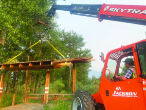 Volunteers from Jackson Contractor Group remove the shade structure that will be replaced when construction of the new fish passage is completed. Photo courtesy of Trout Unlimited. Volunteers from Jackson Contractor Group remove the shade structure that will be replaced when construction of the new fish passage is completed. Photo courtesy of Trout Unlimited.Timberland Excavating will be the lead contractor on the project, with oversight from River Design Group and Trout Unlimited. Great Bear Native Plants of Hamilton will supply native trees and shrubs. Volunteers from Jackson Contractor Group and Bitterroot Trout Unlimited have been instrumental in preparing for work, as has the City of Missoula and Missoula County who are supplying brush for streambank construction. According to Dave Ward, President of the Bitterroot Chapter of Trout Unlimited, although they haven’t gotten official approval from the City of Hamilton, he is pretty confident that the City Council will approve taking about 1,000 willow cuttings from an area in Skalkaho River Park to use in the project. He said they are not uprooting any willows in the park and the area should successfully regrow within a year. His organization will be working together with volunteers from the Trapper Creek Job Corps on building the “exclusion areas” to protect the revegetated area. They have also enlisted the help of student volunteers from the Classrooms Without Walls programs in Hamilton and Corvallis. In total, this effort will plant, fence, and weed mat 300+ trees and shrubs and plant 3,000+ willow cuttings along the banks and floodplain of half a mile of North Burnt Fork Creek. The project was made possible through funding from the U.S. Fish and Wildlife Service, Montana Department of Natural Resources and Conservation, Bitterroot Chapter of Trout Unlimited, Westslope Chapter of Trout Unlimited, Steele-Reese Foundation, Farmers State Bank (Victor Branch), and numerous private donors who came together to meet this need. During construction, several measures will be in place to ensure that in-stream impacts from construction are minimal and temporary. In-stream work will only occur during a window of time that bull trout and other salmonids are least sensitive to in-stream disturbance. Additionally, temporary cofferdams and pumps will be constructed at the culvert/stoplog location to provide localized dewatering during removal and bridged culvert placement. Suspended sediment, stormwater and erosion control structures (e.g., silt fence and silt curtain) will also be in place to limit sediment impacts to the immediate construction area. Visitor access along the trail system may be limited during construction in September and October. Whenever possible the north trail system (Ponderosa Loop) will remain open, but full closures will be necessary at times to keep visitors and equipment operators safe. Signs at the Wildlife Viewing Area parking lot will keep visitors up to date on project progress, trail closures and volunteer opportunities. For questions, contact Refuge Headquarters at 406-777-5552. Lawsuit filed over Sapphire Valley Estates subdivision May 15, 2024 Bitterroot Star by Michael Howell The Bitterroot River Protection Association and two neighboring landowners filed a lawsuit last week challenging the Ravalli County Board of Commissioners’ approval of the Sapphire Valley Estates Major Subdivision preliminary plat. The lawsuit alleges that the commissioners violated both the Montana Subdivision and Platting Act and the county’s own subdivision regulations by not analyzing the potential impacts of the 33 proposed domestic wells and septics on nearby Eight Mile Creek or on the underlying aquifer and the Bitterroot River, among other things.The commissioners held a public hearing regarding the subdivision on February 22, 2024 with a continuance on March 4, 2024 and issued a written preliminary plat approval on April 8, 2024. Members of the public, including plaintiffs, attended these meetings and provided comments in opposition, citing both an incomplete record and failures to adequately assess the subdivision’s potential impacts. The lawsuit challenging the decision was filed in Ravalli County District Court on May 7, 2024.The 49.22-acre subdivision is divided into 33 lots ranging in size from 1.25 to 2.5 acres. Each lot is allotted a residential water supply of 250 gallons per day, or .28 acre-feet of water per year. The total proposed residential water use for the subdivision is 9.80 ac-ft per year. In addition, each lot is proposed to have its own individual water supply for irrigation demand, with such water to be provided by the 49 irrigation shares the developer holds with the Eight Mile Water Company.The plaintiffs allege that neither the applicant’s EA or Community Impact Report, or the county’s staff report or commission’s written approval, evaluate the specific, documentable, and clearly defined impacts of the subdivision on the local aquifer, the water table, or adjacent Eight Mile Creek. They also allege that the county failed to evaluate the impacts of subdivision stormwater pollution or offsite flooding related to impervious development of an agricultural property, which could carry fertilizers, pesticides, herbicides, and other household materials into local groundwater, onto neighboring properties causing damage, or affect surface water quality in Eight Mile Creek, instead relegating such review to state natural resource agencies. They allege the county similarly failed to evaluate the potential for surface or groundwater pollution impacts related to the creation of 33 new septic systems, and application materials failed to provide sufficient water resource data required under the law.Plantiffs are asking the Court for an order declaring void ab initio Ravalli County’s approval of the Sapphire Valley Estates preliminary plat and remanding for reconsideration in light of its lawful mandates as well as a determination and declaration that the approval of the preliminary plat was illegal, arbitrary and capricious, and violates the Montana Subdivision and Platting Act as well as a determination and declaration that it failed to satisfy its own subdivision regulations.Plaintiffs are also seeking determinations and declarations:– that the county’s approval of the preliminary plat violated citizens’ fundamental rights to meaningful public participation, to a clean and healthful environment, and to adequate remedies of law, because failing to assure compilation of a sufficient application or publication of all application materials harms the public’s ability to be informed of a decision’s impacts or meaningfully participate, and because the county’s failure to perform mandatory impact analyses threatens unreasonable depletion and degradation.– that the county’s subdivision regulations do not comply with §76-3-501(i) of Montana Code Annotated because they do not provide for the “avoidance of subdivisions that would involve unnecessary environmental degradation” by failing to account for the cumulative impacts of individual wells and septic systems.– that the Montana Constitution and state law require a county to review the cumulative impacts of a proposed subdivision in conjunction with other existing and pending subdivisions.In a recent District Court decision in Broadwater County in favor of litigants against Broadwater County and the Department of Natural Resources and Conservation (Upper Missouri Water Keepers, et al versus Broadwater County & DNRC), District Court Judge Michael McMahon ruled the county’s approval of that subdivision arbitrary and capricious. In that case McMahon concluded, “The environmental assessment includes only the barest information about water resources; omits necessary information about waters’ health and interaction; fails to consider the impact of exempt wells; and arbitrarily limits its analysis to only the property itself and not neighboring landowners and waters. The County failed to review numerous specific, documentable, and clearly defined impacts to ‘agriculture… the natural environment, wildlife, wildlife habitat, and public health and safety’ raised by citizens, employees and even Commissioners. Although ultimate entitlement to an exempt well is determined by DNRC, the County’s failure to analyze the factual existence and legal appropriability of water for a proposed subdivision abrogates its statutory duty to ‘adopt and provide for the enforcement and administration of subdivision regulations reasonably providing for… the provision of adequate… water… [and] the avoidance of subdivisions that would… lack of water’.”This recent court decision was a recurring theme throughout the discussions concerning the Sapphire Valley Estates Subdivision.Ravalli County Commissioner Greg Chilcott stated on the final day of discussions, “This District Court Decision out of Broadwater County has really thrown a whole new level into the middle of the process in the way that we are expected to do a review. It puts the landowner and his contractors in a tough spot and it puts neighbors in a new position. But it’s in mid-stream and that’s where we are really struggling up here. How do we change gears mid-stream on a court decision 160 miles away from us that may or may not be an impact or may or may not be upheld by our court and affect the way we do business? Heretofore we have had Department of Environmental Quality as our reviewing entity or agency with the expertise, the knowledge and the broad base of studies to review consistently and without being arbitrary and capricious across the state of Montana and made those determinations. Now all of a sudden, some judge in Broadwater County decides to turn all that on its ear and say that we are going to throw local government under the bus to do some higher level of analysis that, quite frankly, many local governments don’t have the capacity or staff to do that analysis. That puts us in a position where…” Chilcott’s statement, 25 minutes into a five-and-a-half-hour discussion, was suddenly cut short for those listening and participating on-line on Ravalli County’s Granicus live-streaming website. The video record is silent for the remaining five hours. The meeting was simultaneously being conducted on the Zoom live streaming platform, but no record of that Zoom meeting was recorded. The County Administrator’s minutes do not include any of the public comments made during that five-hour discussion.Michael Howell, Executive Director of the Bitterroot River Protection Association, who participated on both the Granicus and Zoom platforms, said he was disappointed that his comments and questions cannot be found in the public record.“No one is being thrown under the bus here in Ravalli County,” said Howell. “The commissioners got themselves into this position by shirking their duty to analyze these potential impacts before approving the subdivision, and consistently foisting that responsibility on state agencies after the fact. When DEQ approves these permits based solely on the declaration that they are legally exempt from review, it means that the subdivision and the permits were approved and built out without any environmental analysis of the potential impacts on the aquifer or nearby streams. “If the commissioners continue down this path, the cumulative impacts upon the river could be disastrous and potentially impact the entire river and the entire population of Ravalli County. Montanans have a constitutional right to a clean and healthy environment, and so, too, county government has a responsibility to fully analyze the potential impacts of a new subdivision and base its decision-making on facts.”For further information contact Michael Howell at bitterrootriverprotection@gmail.com or phone (406) 239-4838. |